If you’re a regular follower of mine, you know what I do: I explore metroscapes, where natural and built environments collide. That’s the sexy tagline, anyway.
When I was in Toronto, the longer explanation was that I explored many waterways and green spaces, trying to tell a story, trying to see how far I could go in a continuous path, and highlight where I got interrupted.
This involved some of the better known ravines and stretches of shoreline. But it also involved less trodden paths: smaller tributaries, lost rivers, and hydro corridors. If there was a barrier to doing this, it was usually one of four things: private residences, golf courses, highways or railways. Private property was discussed in, and the inspiration for, my project exploring Toronto’s shoreline. I’ve also written about golf courses, specifically the ones owned by the City.
Now it’s time to address the latter two.
The Legacy of Our Transportation System
Railways and highways can be huge barriers. They are long, linear corridors that cut through a city, often dividing it by severing roads and communities. For railways, this is a legacy of building before the city became dense and built out. For highways, this is a legacy of autocentric planning.
In most cases, it created long uncrossable walls, literally or figuratively. Local roads provide many of the spots to overcome this, and there are a few bridges or tunnels dedicated to those on foot or using pedal power. However, there are parts of the city where it’s a long way between these crossings. It’s not a big deal in a car, and maybe less so on a bike, but it could add many minutes to a one-way trip on foot. This makes neighbourhoods less walkable and can hold them back from their fullest potential.

Many of these railways and highways are not going away anytime soon, and while the pandemic has fuelled much discussion about adequate walking and cycling space on the city’s streets, I feel like this aspect gets forgotten. There should be an effort by the city to build bridges and tunnels across these facilities, better connecting neighbourhoods and decreasing walk and cycle times.
Some Stats
- There are 7 highway corridors in the city, running a total length of 101 kilometres and covering 1,535 hectares (including interchanges).
- There are 12 railway corridors, with a couple owned by Canadian Pacific Railway, and the rest owned by Metrolinx (GO Transit). They run a total length of 186 kilometres and cover 615 hectares, not including yards (which are another 227 hectares).
- There were a total of 307 “segments” analyzed. 187 were railways, 97 were freeways, and 20 were combined/parallel
- The median distance between crossings was about 800 metres. This was larger for highways (969 metres highway vs. 745 metres for railways).
Ranking
I tried to come up with a way to rank all 291 segments in a systematic way, giving weight to:
- Length (duh);¹ ²
- Land use;³ and,
- Feasibility to create a crossing.⁴
- Anything that was less than 240 metres (5 minute walking distance from midpoint to midpoint) was discounted.
- Average walking speed is often cited as 5 km/h, However, this may be considered quite fast. City of Toronto Standard Operating Procedures for signal timing cite a speed of 1.0 m/s (3.6 km/h) for able-bodied pedestrians, and 0.8 m/s (2.9 km/h) for areas where a significant number of pedestrians use assistive devices. The latter speed was used in the length scoring.
- Scoring was ranked (in descending order): Residential or mid- to high-density office, parkland, commercial, industrial. This was a rough estimate based on satellite imagery, and where a mix of uses was present, the two dominant uses on both sides was recorded.
- Feasibility was judged by whether public land (a park) or rights-of way (e.g. a road or road allowance) was available on either side of the corridor. Scoring was assigned to whether or not this was present on both, one or neither side.
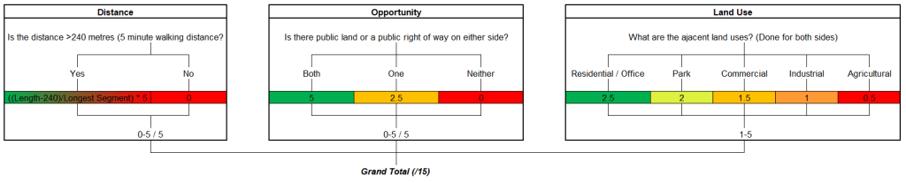
The result is not perfect, of course. It doesn’t account for residential or employment density, socioeconomic needs, the road or trail network leading from the crossing, or the costs / length of a crossing itself. Not to mention that some may find it inappropriately appropriately weighted. But like anything on this site, it’s more of a conversation starter than a definitive conclusion. Anyone can download the data themselves, create their own formulation, and come to their own conclusions.
For now, I have taken this and featured 6 collections of segments (with 1 or more segments in the top 20), and listed 14 more individual segments to make a top 20.
Featured Collectives
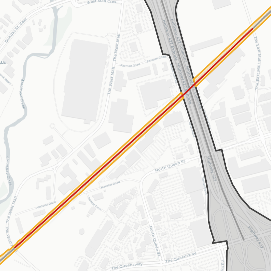
1. West Canyon
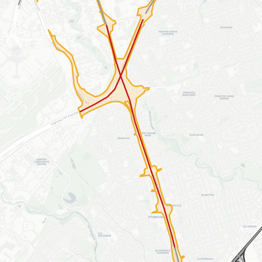
It’s kind of funny to see this on here, because I identified the 401 / 427 interchange as an issue area long ago. It was #2 in my ranking of public golf courses that should be converted to parkland.
However, this analysis makes it clear that the issue extends further south. The segments of the 427 between Dixon Road and Rathburn Road are 1.85 kilometres on average, which can add up to 30-40 minutes to a trip. This can discourage active transportation in the adjacent neighbourhoods of Renforth-West Mall, Markham Wood, Eatonville, Eringate-Centennial, West Deane, Princess Gardens, Willowridge, Richview Park, Martin Grove Gardens and Richmond Gardens.
One notable opportunity towards the north end is to extend the Mimico Creek Trail throught the interchange, and perhaps convert the city-owned Royal Woodbine Golf Club to parkland one day. Further south, plenty of opportunity exists to establish crossings between The West Mall and The East Mall.
2. Highland Creek Wedge

From the far west side to the east side. This one didn’t stick out to me until I took a walk following Adam’s and Smalls Creeks in May 2018. Both the 401 and Highway 2A (a stub of the planned East Gardiner) act to box in the Highland Creek neighbourhood from adjacent Port Union and Rouge Hill. Though it only involves three segments, the two 401 segments are 1,280 and 1,720 metres long (21-27 and 29-36 minutes), and Highway 2A is 2,420 metres long (40-50 minutes).
There are easy opportunities to establish some crossings by joining the dead ends of Meadowvale Road (2A), Centennial Road (2A) and Morrish Road / Sudbury Hall Drive (401). There’s also parklands to link to, namely Dean Park and the corridors / headwaters of Adam’s and Smalls Creeks.
3. Lower Don Valley
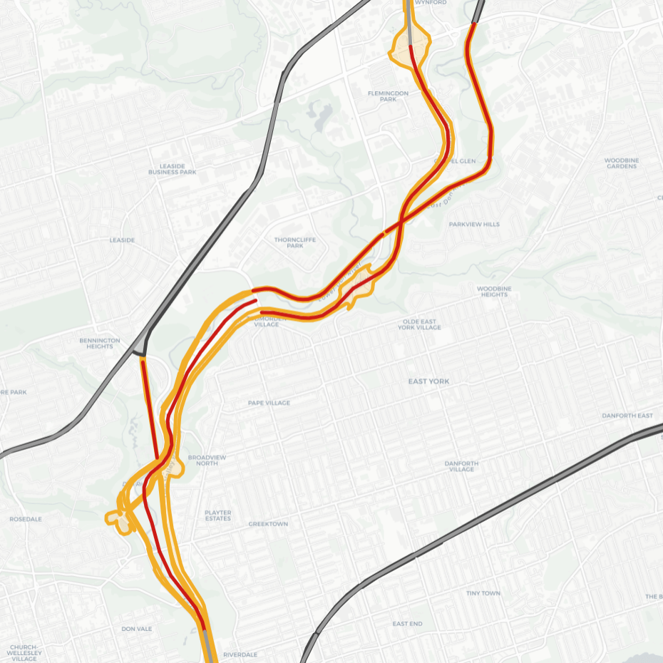
This should not be surprising. Establishing connections across this segment of the Don River valley has been a big part of Toronto’s history. Many 19th century crossings existed and many bridges seen today are second or third replacements, but photogenic monuments from the 1921 old Don Mills Road bridge to the 1918 Prince Edward Viaduct live on.
East-west crossings of the valley east of downtown are now plentiful, with the 5 bridges from Eastern Avenue to the Riverdale Park Bridge averaging 325 metres. But north of here, the gaps are 1.15 km (19-24 minutes) on average. But this also exposes a major flaw in my methodology, in that it does not account for the lateral gap across a corridor. To say the lack of corridor crossings has an impact on neighbourhood walkability would be a huge stretch, as some parts of the ravine stretch 400 to 800 metres across, at minimum.
That said, I’ve left it up here because it does impact connections to and within the parkland. Though there are large feasibility, cost, ecological and natural hazard aspects to creating new connections into the Don Valley, it’s a conversation worth having. The pandemic should have made that clear.
4. North York Wall

I’ve known the 401 to be a wall in this area, but it wasn’t until doing this project that I realized how many significant barriers all clump together here. Overall, there are and one railway segment, and taking out , they average 1.83 kilometres long (30-38 minutes walking). This acts like a huge wall between over 20 neighbourhoods in the former cities of North York and York.
There are plenty of roadways to act as abutting links. In addition, some green pathways could be forged by restoring some lost (buried) creeks, including Meadow (Keele to Dufferin), Yellow and/or Mud (401/Allen interchange), Wilket (Yonge to Bayview), and Vyner (Bayview to Leslie). Converting another golf course to parkland (Don Valley, #1 in my ranking of public golf courses) would greatly improve the stretch between Avenue Road and Yonge Street.
7. Warden Greenway
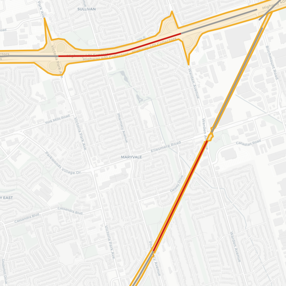
Yet another seemingly no-brainer of a connection I identified in my many walks, and it’s great to see the numbers backing it up. These are two segments that are west of Warden Avenue, one being Canadian Pacific’s Belleville Subdivision and the other being the 401. Both are around 1,275 metres (21-27 minutes).
What’s notable about these two segments, and the reason they rank so high, is because there is one easy opportunity to link them via the Warden Hydro Corridor, which runs up through both of them. This is not just a typical hydro corridor however, as it appears to no longer be in use. It presents a huge reforestation and trail opportunity, and crossing these corridor segments could be part of it. It has even been proposed to re-align Taylor Massey Creek through this corridor to improve its health.
8. East Danforth – Beaches

This one flew under the radar for me. I had noticed the parallel alleys and the lack of grade-separated connections over the cross streets, but not the significance of the distances between. This railway corridor is part of GO Transit’s Lakeshore East Line, and VIA Rail’s route between Toronto and Ottawa/Montreal. The four segments in question are between Coxwell and Warden Avenues. The average distance between streets here is just over 1 kilometre, or 18-22 minutes.
There are a few adjacent dead ends or parallel roadways to make a connection. However, one significant opportunity is the Small’s Creek Ravine, which is one of a couple small East York creeks that have not been buried yet. Parkland flanks both sides, separated by the railway berm. However, recent Metrolinx expansion work has failed to establish this as a bridge that it should be.
The Rest of the Top 20
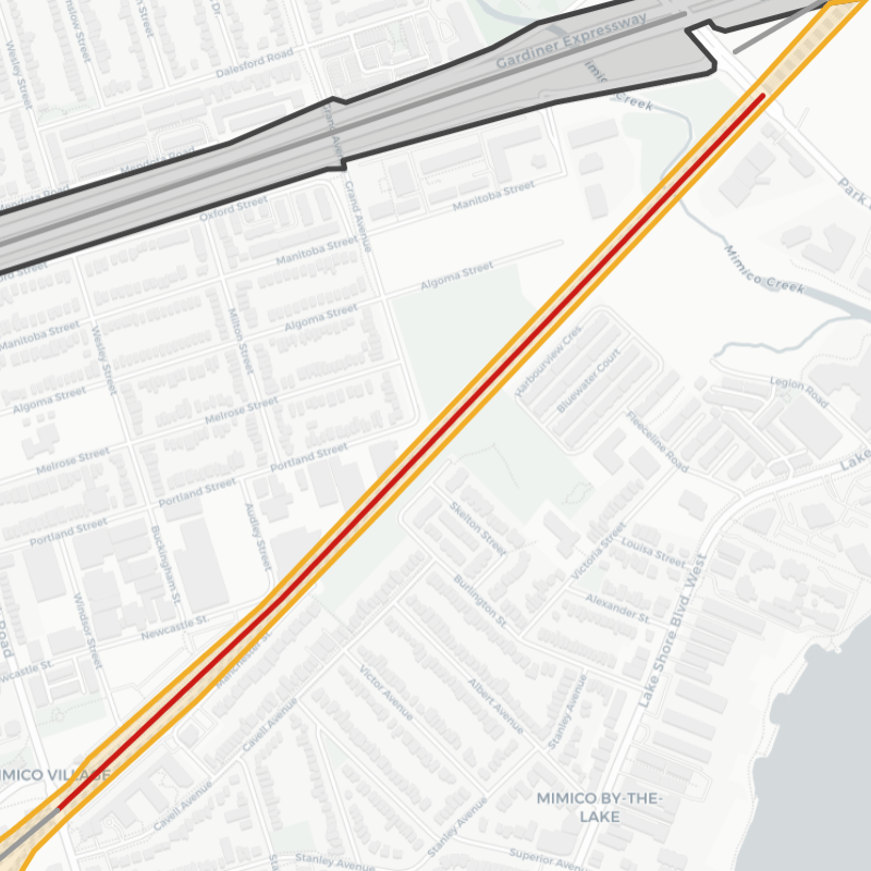
#5: Mimico Split
Corridor:
Termini:
Distance:
Land Use:
Connection:
Oakville Subdivision
Royal York Rd / Park Lawn Rd
1,480 m
Residential / Residential
Grand Ave / Manchester Parks
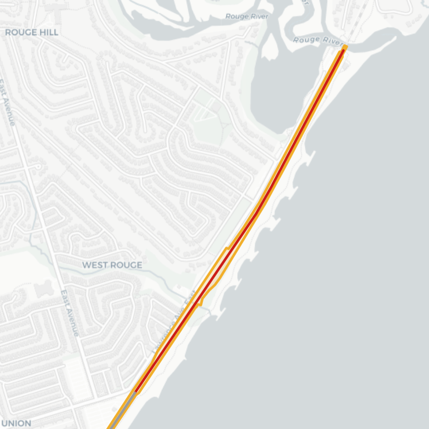
#6: East Beach
Corridor:
Termini:
Distance:
Land Use:
Connection:
Kingston Subdivision
Chesterton Shores / Rouge River
1,740 m
Residential / Park
Starspray Boulevard
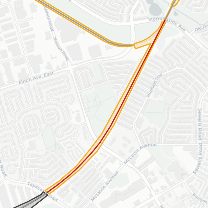
#9: North Malvern
Corridor:
Termini:
Distance:
Land Use:
Connections:
Belleville Subdivision
Tapscott Rd / Morningside Ave
613 m & 1,170 m
Residential / Residential
Horseley Hill Park & Maidenhair Ln

#10: Finch Hydro
Corridors:
Termini:
Distance:
Land Use:
Connection:
Bala Subdivision & Highway 404
Finch Ave E / McNicoll Ave
1,110 m & 878 m
Residential / Residential
Finch Hydro Corridor

#11: Highland – Malvern
Corridor:
Termini:
Distance:
Land Use:
Connection:
Highway 401
Progress Ave / Neilson Rd
1,590 m
Residential / Commercial
East Highland Creek – Malvern Branch

#12: Lambton Lead
Corridor:
Termini:
Distance:
Land Use:
Connections:
Galt Subdivision
Humber River / Jane St
1,150 m & 629 m
Residential / Residential
Lambton Arena & St Clair Ave W / Dundas St W
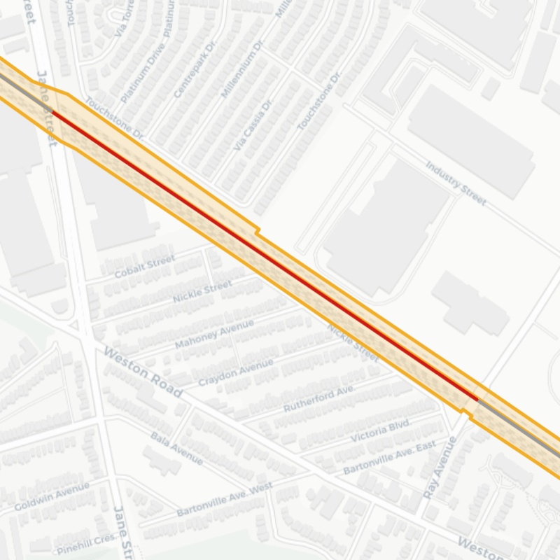
#13: Brookhaven – Mt Dennis
Corridors:
Termini:
Distance:
Land Use:
Connection:
Weston & Mactier Subdivisions
Jane St / Ray Ave
837 m
Residential / Residential
Touchstone Dr / Cobalt St
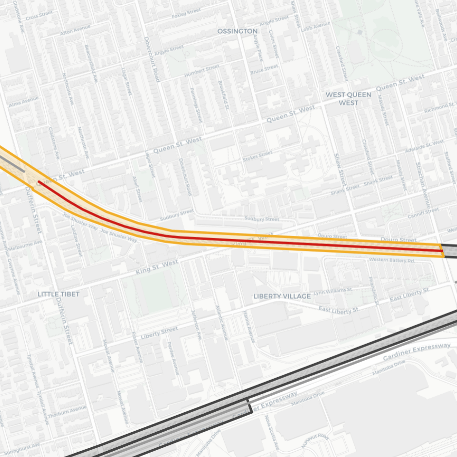
#14: Upper Liberty
Corridor:
Termini:
Distance:
Land Use:
Connection*:
Weston Subdivision
Queen St W / Strachan Ave
755 m & 637 m
Residential / Residential
Joe Shuster Way / Sudbury St
* Note: The segment from King St W to Strachan Ave will be addressed by the completion of the King-Liberty Pedestrian/Cycle Bridge.
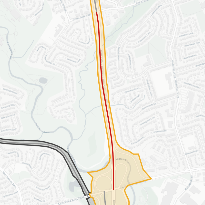
#15: Parkwoods – Don Mills
Corridor:
Termini:
Distance:
Land Use:
Connection:
Don Valley Parkway
East Don Trail / York Mills Rd
723 m
Residential / Residential
Deerlick Creek Tributary
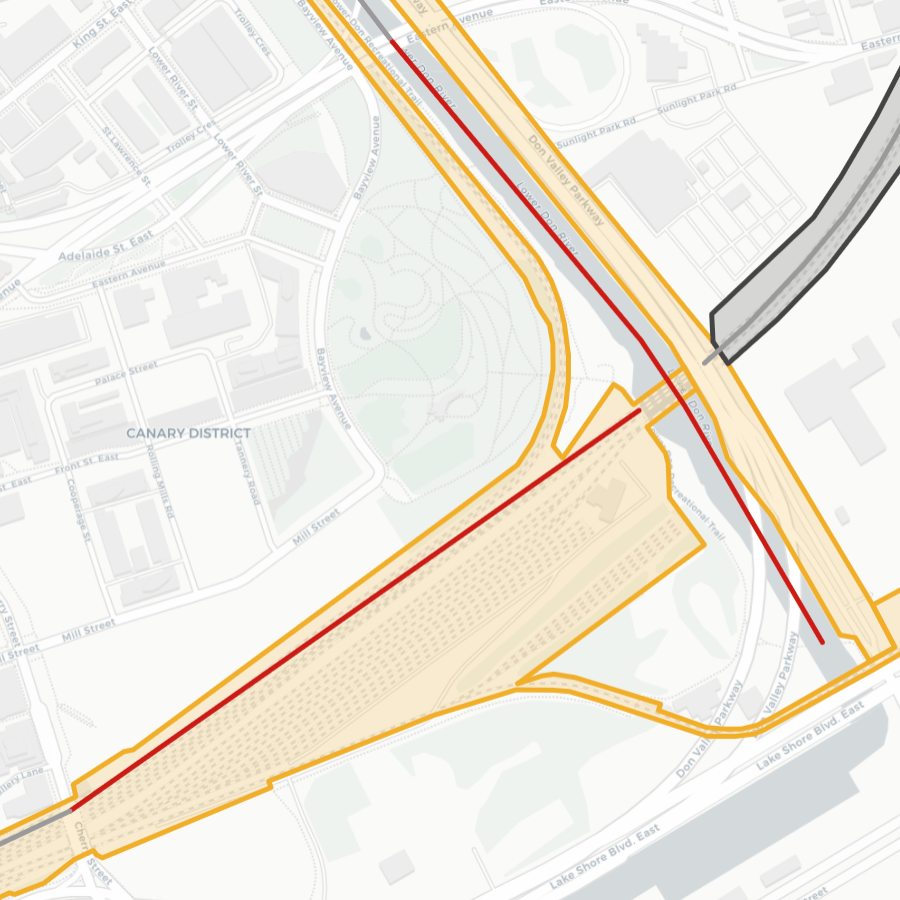
#16: Corktown Corner
Corridors:
Termini:
Distance:
Land Use:
Connection:
Don Valley Parkway & USRC
Cherry St / Eastern Ave
665 m & 707 m
Residential / Office
Bayview Ave
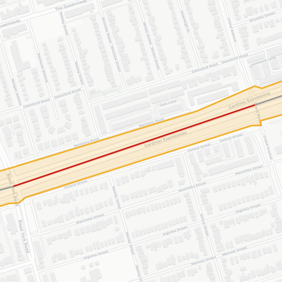
#17: East Queensway
Corridor:
Termini:
Distance:
Land Use:
Connection:
Gardiner Expressway
Royal York Rd / Grand Ave
672 m
Residential / Residential
Wesley St
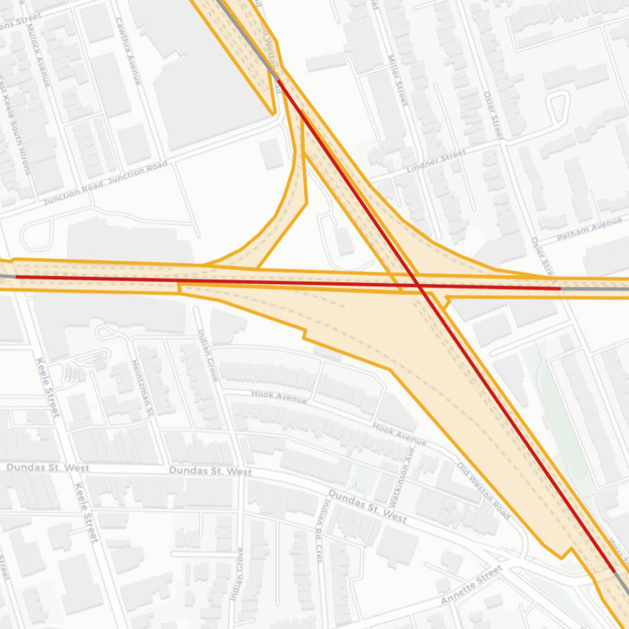
#18: West Toronto Diamond
Corridors:
Termini:
Distance:
Land Use:
Connection:
Weston, Mactier, Galt and North Toronto Subdivisions
Cherry St / Eastern Ave
647 m & 592 m
Residential / Commercial
Old Weston Rd / Miller & Lindner St
#19: The Malls
Corridor:
Termini:
Distance:
Land Use:
Connection:
Galt Subdivision
The East Mall / The West Mall
1,780 m
Commercial / Commercial
Norris Glen Rd / Index Rd
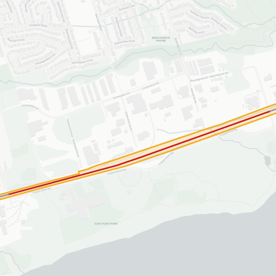
#20: East Point Edge
Corridor:
Termini:
Distance:
Land Use:
Connection:
Kingston Subdivision
Manse Rd / Beechgrove Dr
1,680 m
Industrial / Park
Chemical Ct
Stats and Mapping
| Railways | Highways | |
| Length | 197 km | 120 km |
| Area | 883 ha | 1,676 ha |
| Average Width | 33 m | 140 m |
- There were a total of 307 “segments” analyzed. 187 were railways, 97 were freeways, and 20 were combined/parallel
- The median distance between crossings was about 800 metres. This was larger for highways (969 metres highway vs. 745 metres for railways).

Open Data
This dataset is available in multiple formats through the Open Data Portal


Love your blog. It’s been really useful for identifying interesting hikes and bike rides to take, plus highlights the many barriers that still exist to be non-auto connectivity in and between neighbourhoods.
LikeLike
I’m glad it’s useful, that’s exactly why I made it in the first place!
LikeLike
Fascinating and a valuable insight that hopefully will inform future trails and crossings.
LikeLike