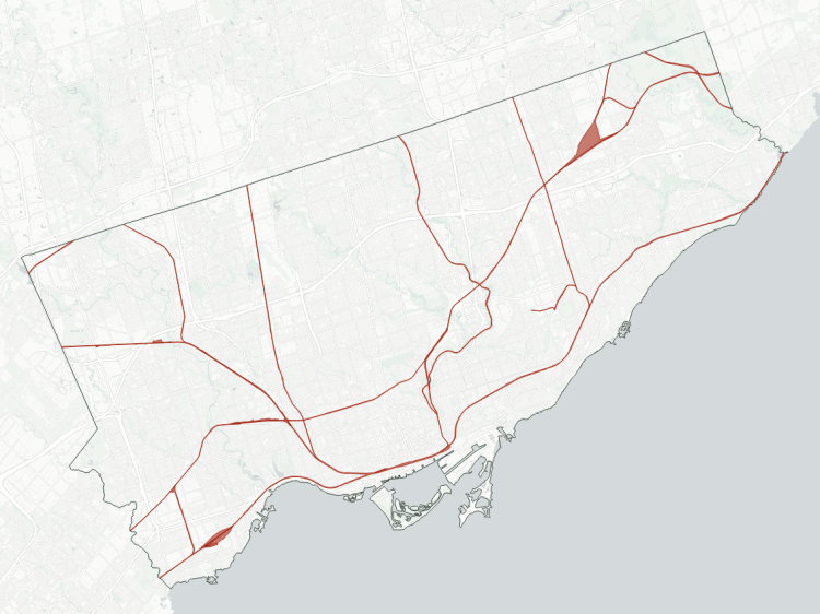
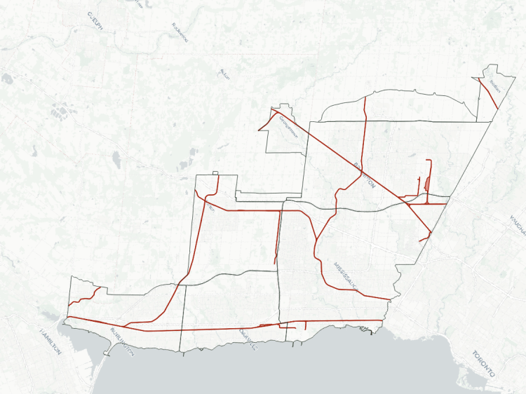
Rails in Niagara are strange. There are old lines stretching back to pre-Confederation Canada like in other jurisdictions, but the Welland Canal and associated industrial activity has changed the face of the railroad landscape (railscape?), both physically and figuratively. It’s interesting what happens when major historic corridors intersect with new branches and spurs from the marine-based facilities.
- Grimsby Subdivision
- Hamilton Subdivision
- Trillium Railways
- Stamford Subdivision
- Humberstone Spur
- Montrose Subdivision
- Grantham Spur / Lakeshore Spur
- Other Leads and Spurs
- Notes / Disclaimers
- Explore Railways in Other Cities
Grimsby Subdivision
| Area | 93.8 ha |
| Length | 21.0 km |
| Average Width | 45 m |
| Tracks | 2 |

The Grimsby Subdivision is CN’s international connection between southern Ontario and CSX lines in upstate New York, providing access to the US eastern seaboard. Many folks will probably recognize this as the route of GO Transit Niagara trains, or Amtrak’s route from Toronto to New York. It was one of the first railway lines constructed in southern Ontario, completed by the Great Western Railway in 1854.
In 1855, the Niagara Falls Suspension Bridge opened across the Niagara River into New York state, making it a key conduit for transport and trade between the US and pre-confederation Canada. In addition to extending the Great Western Railways’ Grimsby Subdivision, it also connected the New York Central Railroad, as well as the New York and Erie Rail Road, all of which had different gauges (different spacing between the rails). This bridge was replaced by the Whirlpool Rapids Bridge in 1897, which is the same bridge that stands today.
The line is fairly straight, with a couple key junctions to southerly lines on both sides of the Welland Canal. At the canal, a bridge sits atop the lower gates of Lock 4, and it lifts up to let ships go in and out. A large amount of land used to be a rail yard near the border, but all of its tracks were lifted sometime in the late 2000s.
Some of the Bruce Trail zigzags through wooded areas near the tracks in Niagara Falls, and even spans over the QEW in parallel. Otherwise, this corridor is a significant barrier. There’s huge potential for this corridor to be a link for active transportation across across the Welland Canals and the valley of Twelve Mile Creek.

Hamilton Subdivision
| Area | 107.0 ha |
| Length | 6.6 km |
| Average Width | 161 m |
| Tracks | 1 |
The statistics may seem weird for this corridor; it has the largest area and widest average width of all Niagara corridors. But it makes sense when you realize most of the area is because it includes the large embankments of the Townline Tunnel, which goes down under the Welland Canal. Unlike CN’s bridge at Lock 4, this tunnel allows for uninterrupted access under the canal without any consideration for Seaway operations.
While parts of this line west of Welland were part of the former Toronto, Hamilton and Buffalo (TH&B) Railway, it never reached Buffalo. TH&B was purchased jointly by Canadian Pacific Railway and New York Central Railroad in 1895, serving as a bridge between those rail networks. In this area, though, the connection was further north. The current tunnel was opened to rail traffic in 1973 as part of the Welland Bypass, where the canal was realigned to the east side of the town of Welland.
The Townline Tunnel includes a sidewalk, although the air quality and odour is notoriously noxious. The wide embankments are also a barrier for pedestrians and cyclists going between southeast Welland and Dain City.

Trillium Railways
| Area | 130.3 ha |
| Length | 40.3 km |
| Average Width | 32 m |
| Tracks | 1 |
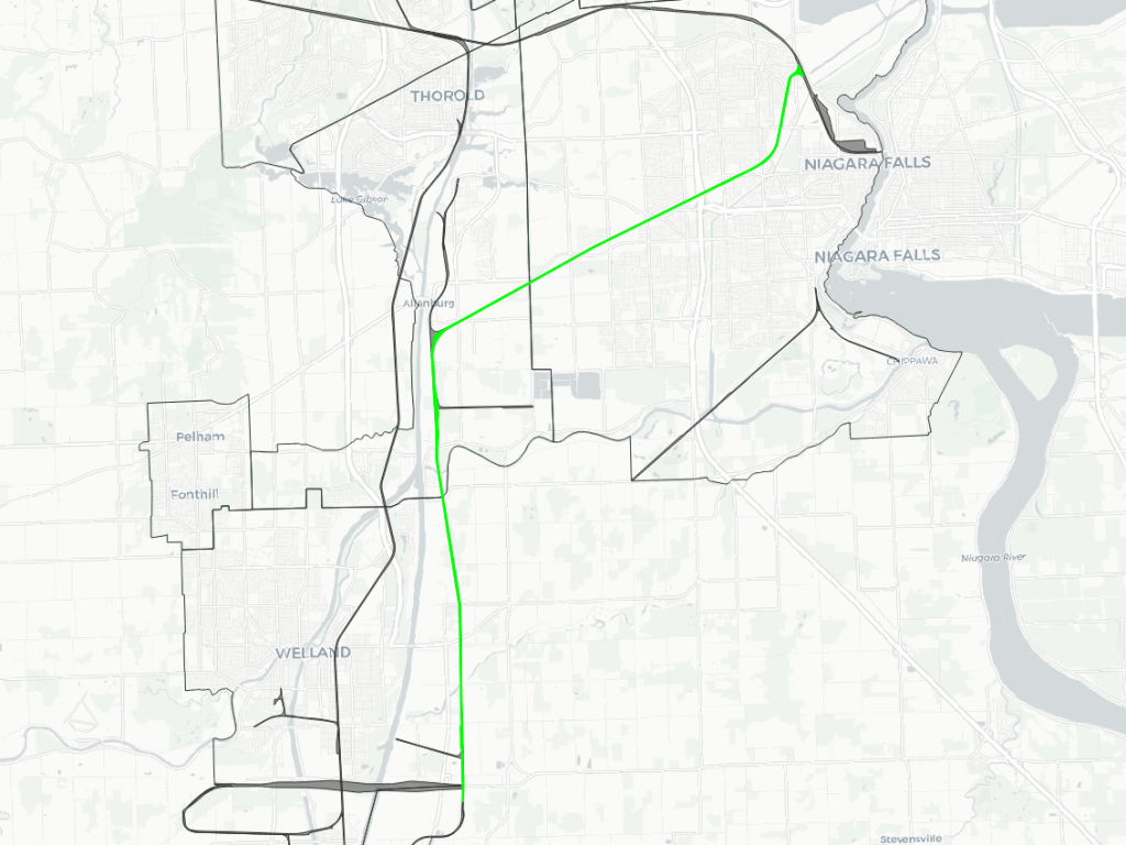
Trillium Railway owns a series of lines that are all connected, acting as a route from St Catharines to the lake at Port Colborne.
On the west side of the Welland Canal, the Thorold Subdivision splits off of the Grimsby Subdivision and parallels Locks 4-7. As it reaches Lake Gibson, it historically crossed over the Welland Canal via Bridge 10, a historic lift bridge that was removed in 1998.
With the bridge gone, the line simply continues south as the Canal Spur, this takes trains over the recreational canal and the Welland River onto the island forming the east part of town. It crosses over a 320 metre (1,050 foot) long, 20 metre (65 foot) tall bridge over the CPKC Hamilton Subdivision, which uses the Townline Tunnel to go under the Welland Canal. The spur continues south before bending west to cross the recreational canal again at Bridge 17.
West of Dain City, trains can use the Feeder Spur to loop around and connect to CPKC’s route through the Townline Tunnel. Otherwise, they can continue south via the Harbour Spur into downtown Port Colborne. From here, one more turnout onto the Government Spur allow trains to reach the grain and flour terminals at the foot of King Street.
Overall, like many other shoreline railways, these lines don’t present a large barrier to active transport. The Welland Canals Parkway Trail crosses or parallels the tracks in many places, and where there are barriers to neighbourhood connections (e.g. east Welland), it’s moreso due to the street and highway network rather than the rail corridor. Great connection opportunities exist where the tracks cross the Welland Recreational Canal, Welland River, Highway 406 and Townline Tunnel Road.
Stamford Subdivision
| Area | 130.3 ha |
| Length | 40.3 km |
| Average Width | 32 m |
| Tracks | 1 |
CN’s connection from the Grimsby Subdivision (and the rest of it’s Ontario rail network) used to be via the Thorold Subdivision. When Bridge 10 was removed in 1998, the only remaining route was the Stamford Subdivision, which connects near the Beck Generation Station complex in Niagara Falls. This allows CN trains to travel south and east to Fort Erie, and across the Niagara River into Buffalo.
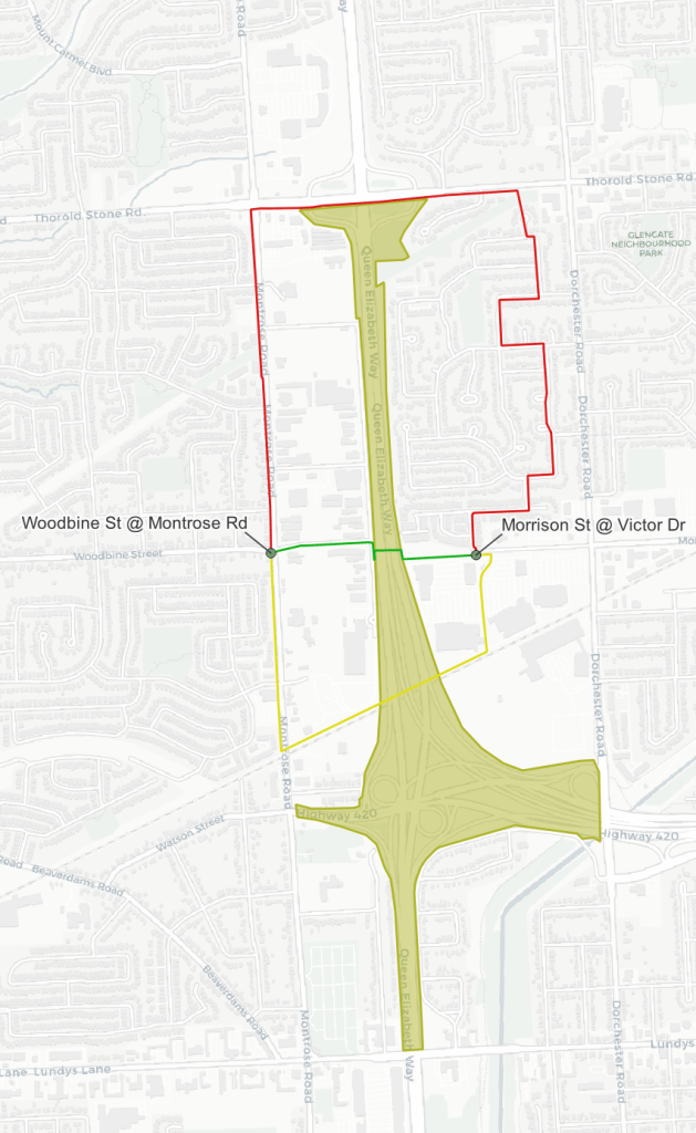
Much of the corridor is currently in rural areas south of Niagara Falls. It’s crossing under the QEW contributes to one of the largest barriers to active transportation I’ve seen in southcentral Ontario to date. The walking distance between Woodbine Street / Montrose Road and Morrison Street / Victor Drive is 3.8 km (see map below; 🟥). Google says that is 52 minutes of walking. A direct pedestrian bridge over the QEW could cut that down to 800m / 11min (🟩). Using the Stamford Sudivision’s existing rail tunnel / bridge (🟨) would cut it down to 1.8km / 25min.

Humberstone Spur
| Area | 29.8 ha |
| Length | 10.0 km |
| Average Width | 30 m |
| Tracks | 1 |
After the Townline Tunnel, while CN’s Stamford Subdivision wyes eastward towards Fort Erie and Buffalo, the Humberstone Spur continues south to Port Colborne. The City of Port Colborne purchased this line around the turn of the century, and it currently runs to a spur into the Vale (formerly Inco) property. Liquid chlorine was transported in by rail, but this was eliminated as part of Vale’s transition to bleach in 2020.
This corridor doesn’t present a huge barrier to pedestrians or cyclists, but could benefit from a couple formalized crossings.

Montrose Subdivision
| Area | 26.9 ha |
| Length | 10.2 km |
| Average Width | 26 m |
| Tracks | 1 |
The Montrose Subdivision was CP’s route through downtown Niagara Falls towards, and over the Niagara River. In 2001, CP and the City of Niagara Falls struck a deal to abandon the line between the Michigan Central Railway Bridge (immediately south of the Whirlpool Rapids Bridge) and Fallsview Casino. Nowadays, the steel ends near Livingstone Street, and the remainder of the line is predominantly rural, connecting with the Hamilton Subdivision and CN lines to Buffalo. In addition to a suphuric acid distributor, the remaining spur past Marineland connects to a ceramics plant.

Grantham Spur / Lakeshore Spur
| Area | 15.5 ha |
| Length | 4.9 km |
| Average Width | 32 m |
| Tracks | 1 |
This line is what’s left of a line that connected along the old Welland Canal, and went north to downstream of the Martindale Pond outlet where rails met hulls. Now it exists as a smaller spur to chemical, metals and warehousing customers in eastern Queenston.
Other Leads and Spurs
- CN Thorold Spur and Coniagas Spur: Connections to multiple industrial manufacturers upstream of Welland Canal Lock 7.
- Chemical Spur: As the name suggests, a line to chemical / vinyl plants and a haz-waste handler near Port Robinson.
- Welland Tube Spur: Connections to steel pipe and construction panelling warehouses across the canal from Welland’s island.
- Welland Industrial Lead: Link to a specialty metal manufacturer in west Welland.
Notes / Disclaimers
- This data was drawn interpretively, using the Railway Association of Canada’s Canadian Rail Atlas as a general reference. Some interpretive refinements were made, and due to a lack of open parcel data, the exact extent of railway property is a best guess outside of the City of Niagara Falls. Therefore this data is provided ‘as is’; please refer to additional disclaimers at the Open Data page.
- While this website advocates for greater active transportation access across and parallel to railways, they are private property and are dangerous places. DO NOT trespass on railways; over 100 Canadians are killed or seriously injured trespassing on or crossing railways each year. Remember that train time is anytime.
This dataset is available in multiple formats through the Open Data Portal