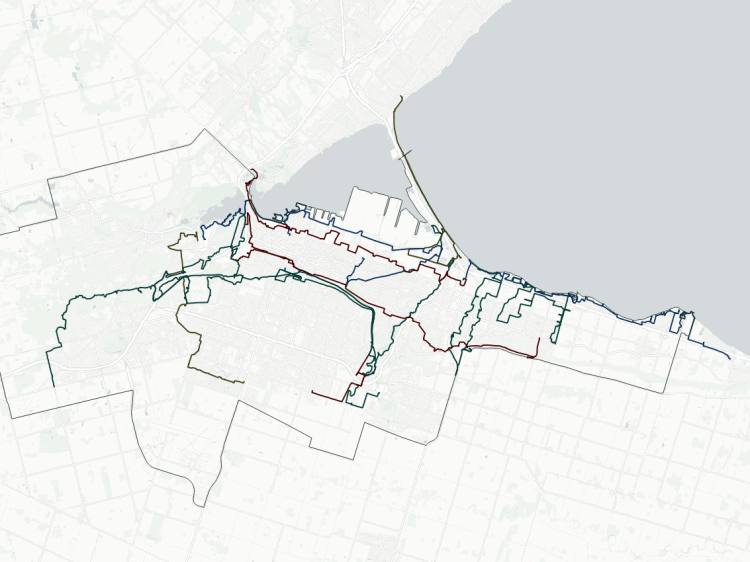
A major trigger to expand Metroscapes into what it is today started with analyzing the public and private ownership of Toronto’s shoreline. So I have continued that breakdown westwards.
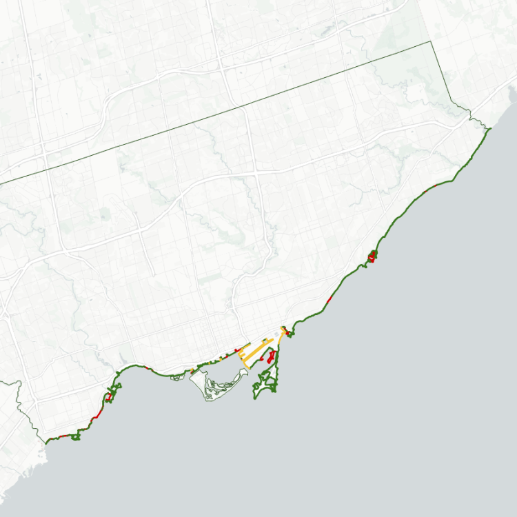
The West GTA’s shoreline technically starts at Applewood Creek, but I use the more practical boundary at Etobicoke Creek. It then stretches along Mississauga, Oakville and Burlington to Grindstone Creek, at the northwest corner of Lake Ontario. As the crow flies, that’s 43 kilometres from border to border. But the total length of the West GTA’s shoreline is extended by peninsulas, piers, inlets and a sand bar to just under twice that length: 72 kilometres.
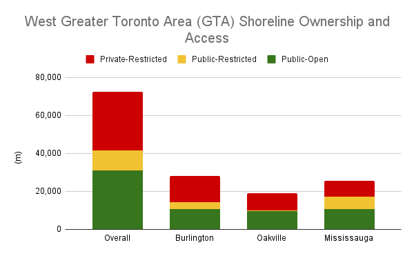
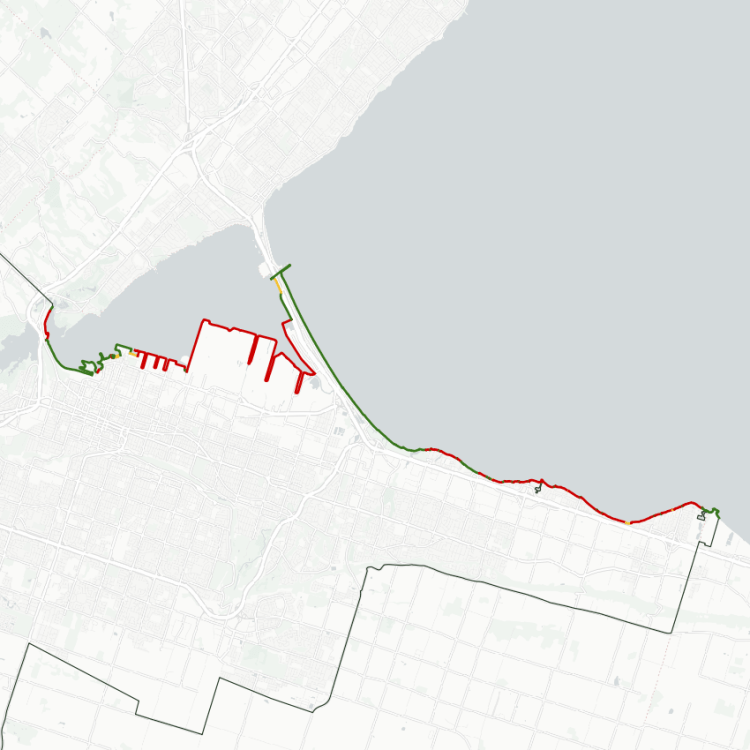
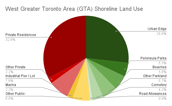
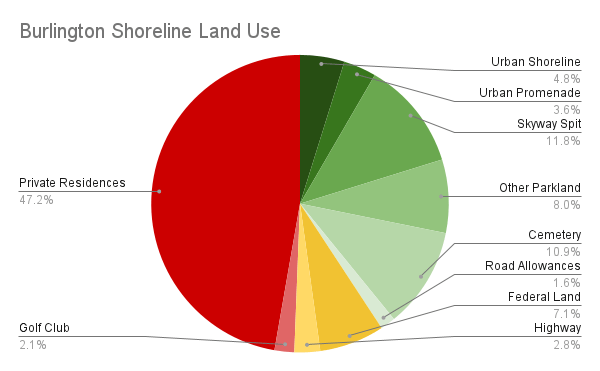
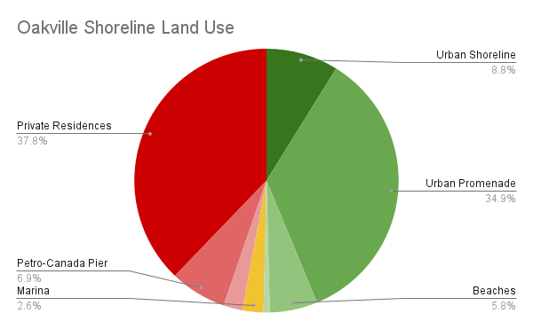
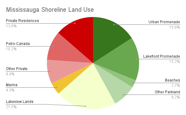
Overall, only 43% of the West GTA’s shoreline is publicly accessible. It’s fairly well distributed between the three cities, and over a quarter of it is made through hardened urban edges, whether it’s a concrete/steel wall against the water or lining the edge of the lake with massive armourstones. Another 8% solely exists as Mississauga’s Lakefront Promenade Park and Burlington’s Beach Spit, and the rest is divided through various other beaches, cemeteries and other parks.
About 14% of the West GTA shoreline is publicly-owned, but restricted from public access. Over half of this is tied up in Mississauga’s Lakeview Lands, where new parkland is being built south of a wastewater treatment plant, and the adjoining inlet to a coal generating station will be redeveloped into public space for adjacent residential development. Another 2% is blocked off by public marinas, and the remainder 4% is split between part of the Burlington Skyway and the Canadian Centre for Inland Waters.
The rest of the West GTA shoreline is privately owned and inaccessible. One-third of the shoreline is taken up by private residences. Another 8% can be split between Petro-Canada’s complexes / piers in Oakville and Mississauga, as well as a Mississauga aggregate plant. The remaining 2% consists of a telecommunication tower field, Appleby College, and the Burlington Golf and Country Club.
The Lakeview area is a bright spot in the future of the West GTA’s shoreline. There may be other opportunities for public promenades on private or public-restricted lands. But otherwise, opening things up will be along game of attrition with individual properties.
Notes:
- Some of these numbers were obtained by hand-drawing lines along the shore using the latest available open orthoimagery. Within Mississauga, it was refined based on open parcel data from the City of Mississauga Open Data Catalogue. See Licensing and Disclaimers for more info.
- The shoreline may be subject to negligible fluctuations due to lake elevation, shoreline erosion / shifting due to other natural phenomena, human modifications (private developments, public infrastructure work, etc.), or the accuracy / vintage of the map imagery itself. It’s not ultra-precise, but accurate enough to portray the broad picture.
- Some shoreline length is accounted for by inlets and other channels that extend inland, and peninsulas that extend out into the lake. While this may mean there is ‘1 kilometre of shoreline’, it may be only a few dozen metres as the crow flies between connecting points on the mainland. Some liberties were taken to exclude some breakwaters and groynes that do not add value to public access.
- Marie Curtis Park is technically within the City of Toronto. For practical purposes, Metroscapes considers Etobicoke Creek to be the border all the way south from Lakeshore Road.
Open Data
This dataset is available in multiple formats through the Open Data Portal